


Shra
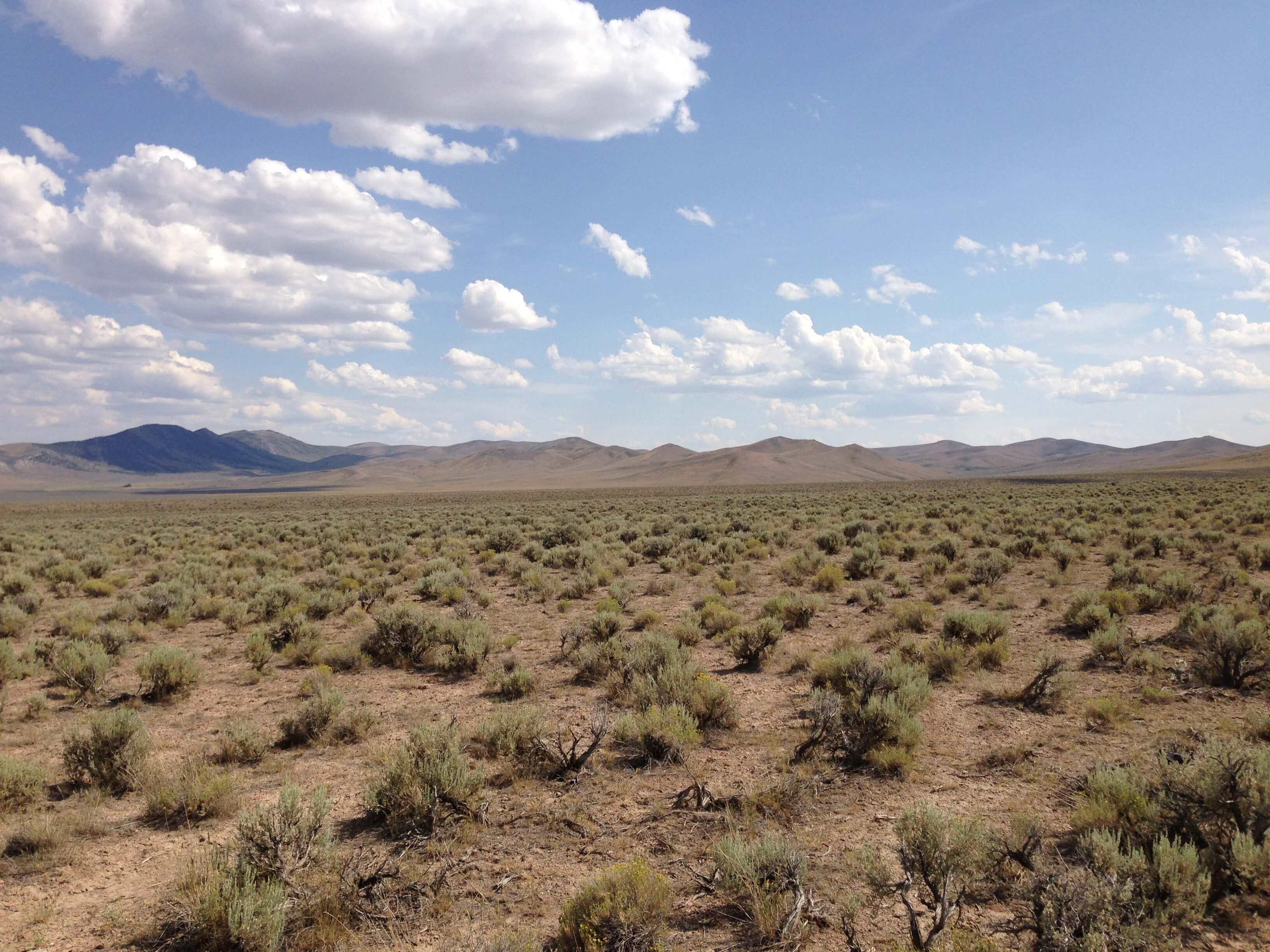
When the people talk about Shra, they generally speak about its inhabited region. This is a vast area, though only a minor part (less than 2%) of the total surface of the planet. Shra is a basin, wedged between mountains and highlands. Because of its low elevation, water from the surrounding areas flows into it, making it somewhat hospitable. There are no permanent rivers or streams, just wadis ("yazar") and underground aquifiers. On water-rich planets the Shra basin would have been a sea or ocean, yet on this dry world it is just a desert with a number of oases. Outside the Shra region the land is so parched that no sane people venture out there.
Terrain
The people of Shra generally discern the following types of terrain:
|
Adrar:
These are true mountains, often jagged peaks. Cold, windswept and barren, they are even more inhospitable to people than the desert in the lowlands. |
|
|
Tawjja:
These are hills, rising above the plains like mountains, though not so high. The people of Shra have no clear distinction between hills and mountains. In general low peaks and/or shallow slopes are called hills, others mountains. |
|
|
Imru:
Would be called badlands on Earth. Erosion has cut away the softer rocks, while the harder ones keep standing. This creates an irregular landscape. There is little soil for plant roots to get a grip on and at the rare times that rain falls, it quickly leads to flash floods. |
|
|
Tisnti:
When wadis are filled with water that flows down into the lowlands they often create temporary lakes. Much water evaporates, however the minerals stay behind. This creates salt lakes, wet in spring and barren the rest of the year. |
|
|
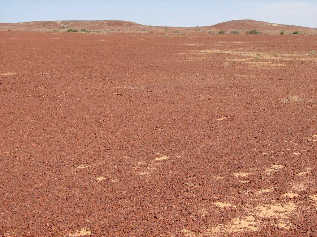
Reg:
On Earth this is also called desert pavement, gibber and other names. It is made of of small stones, partially eroded to roundish shapes. They interlock to a large degree, with smaller grains in between, covering and hiding the sand underneath. The result is a relatively smooth, hard surface that is good for walking or riding but hard for plants to take root in. |
|
|
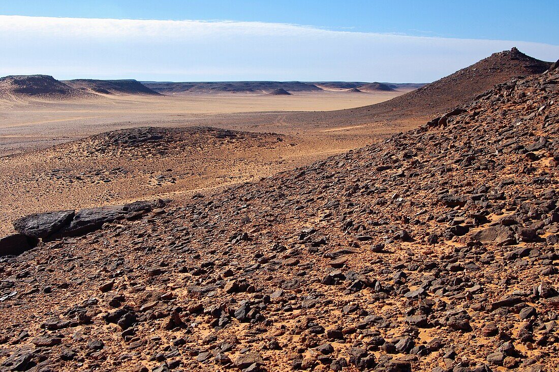
Izr:
On Earth this is called hamada in Arabic. Here the stones are larger than in reg, rougher and partially embedded in sand. It basically is coarse gravel. Dromedary camels dislike it because their soft feet are ill equipped for the hard sharp edges of the stones. |
|
|
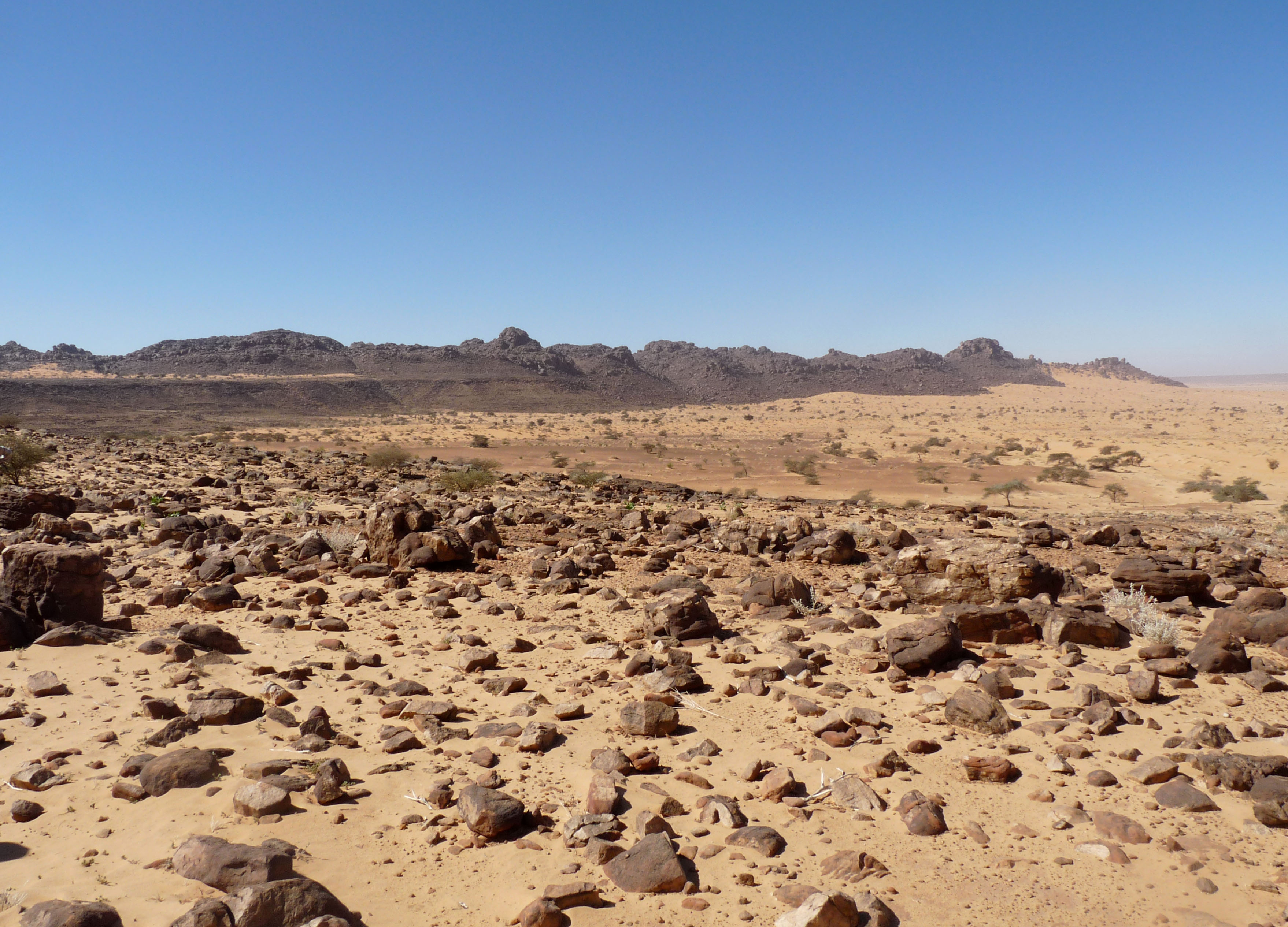
Aghuld:
This type is not to be confused with izr. The stones are larger on average, including small and medium boulders. In between them, there are significant amounts of pebbles and sand. Travelers must zigzag among the larger boulders. Aghuld is the most common terrain type in Shra. |
|
|
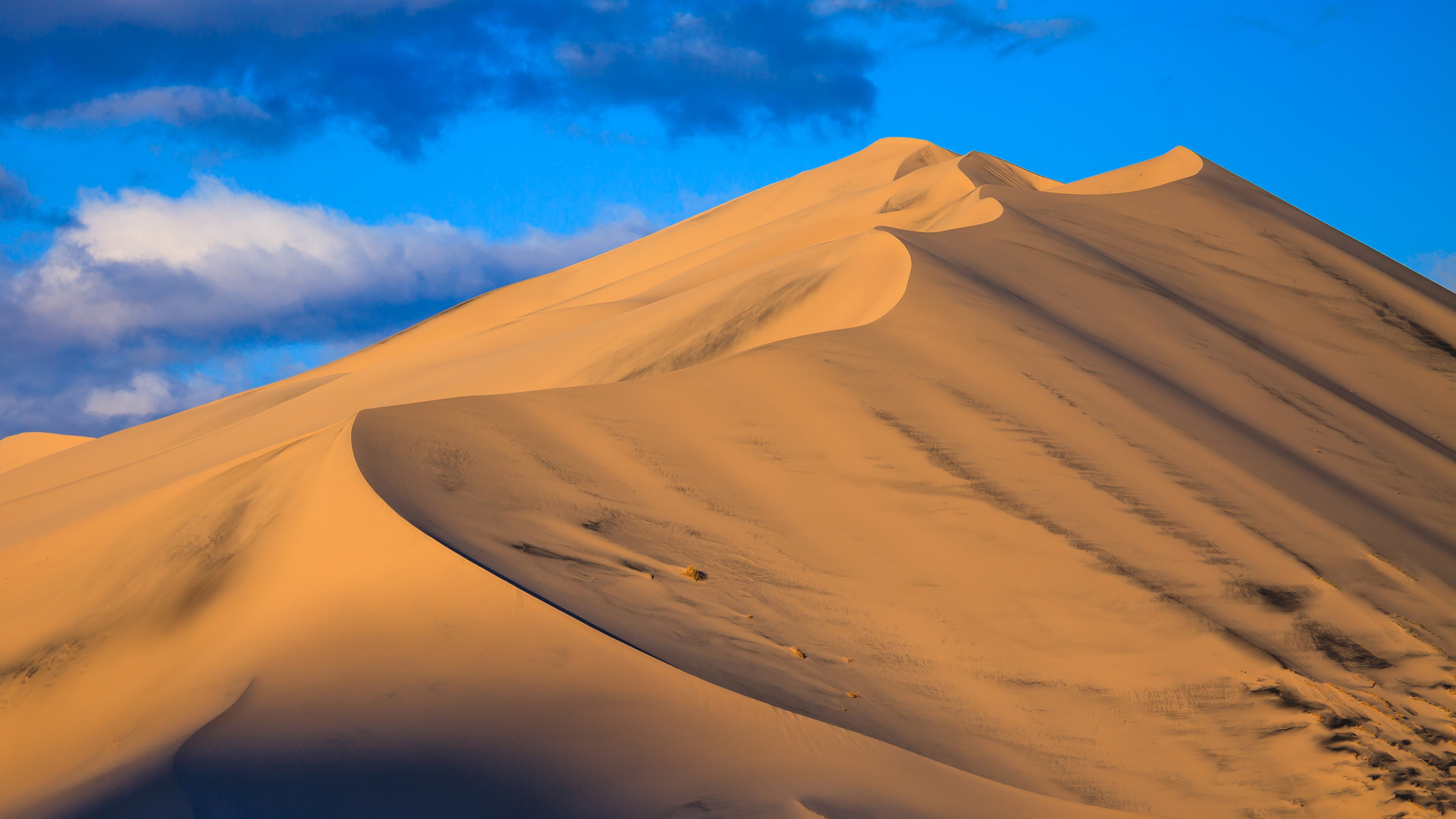
Erg:
This is what most people imagine deserts to be like: areas of loose sand, sometimes flat but more often forming dunes. Some are relatively stable, while isk (usually called barchans on Earth) slowly move around, pushed by the wind. The latter are feared by the people, as they can engulf oases and bury them completely under their sand. |
|
|
Ifssiy:
What the people of Shra call shrubland would be marked as xeric shrubland, scrub desert or shrub steppe on Earth. It is ground covered with numerous yet not overcrowding shrubs, which fight an everlasting battle against Shra's grazing animals. |
|
|
Anua:
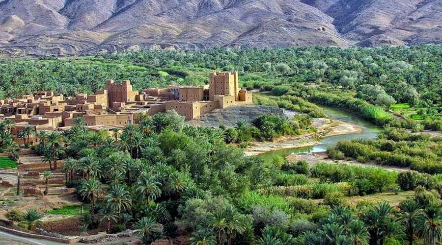
Oases in Shra range from small, able to support a handful of families, to large, giving rise to towns. All are treasured by the people and coveted by rulers. |
|
Overview map
Shra is a little smaller than the Sahara on Earth. The area displayed on the overview map below is 3840 x 2160 kilometers. All major and most minor landmarks are shown. Small wells and waterholes, vital for desert travel, are not marked.
Color legend:
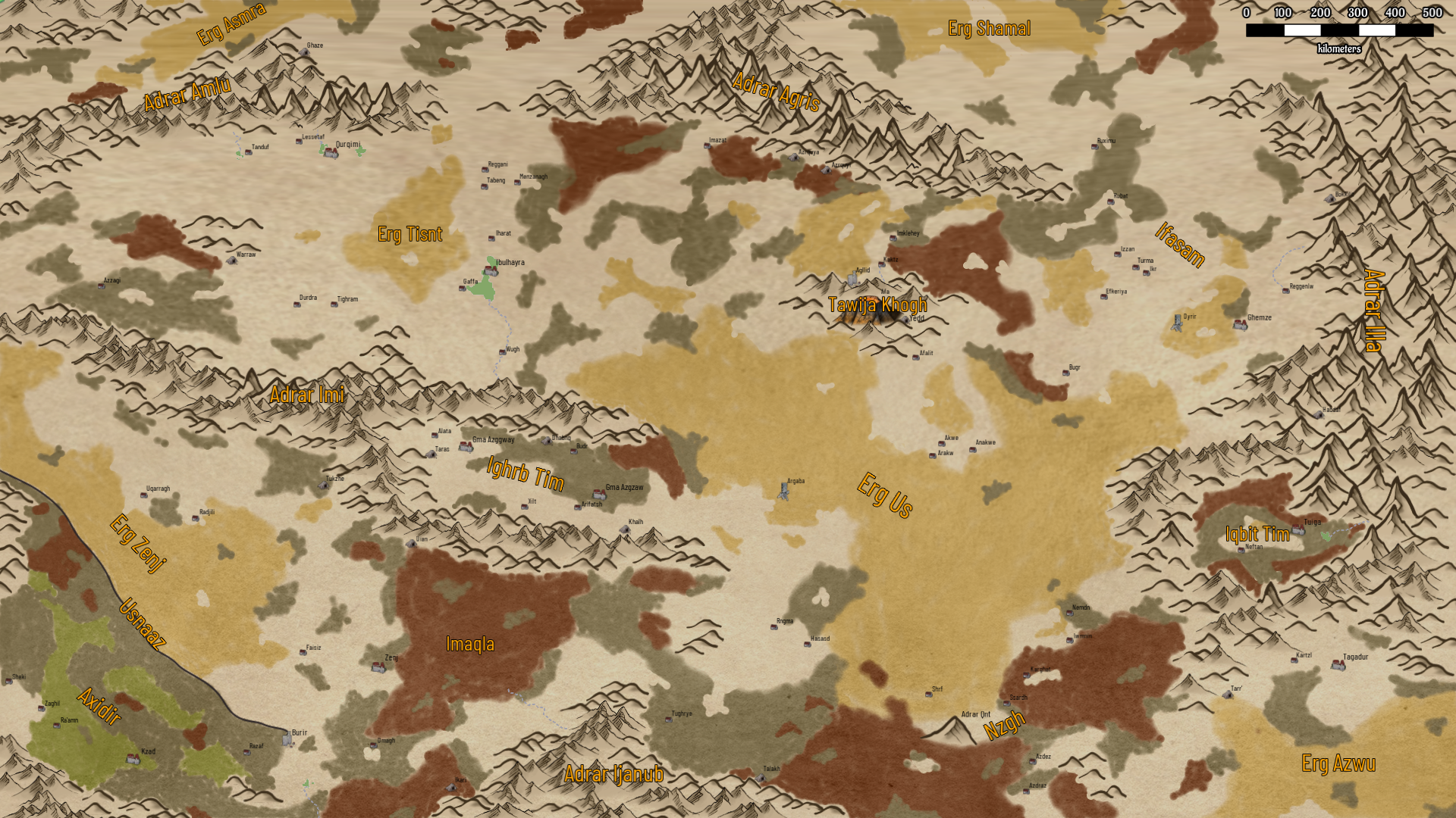
This map was created with Wonderdraft.
Landmarks
Because of racial hatred most settlements are inhabited by either humans or surre, but not both. The current occupancy is included in the table below. Note that this has not always been so; warfare in Shra is endemic and sometimes settlements change ownership.
| Name | Races | Description |
| Adrar Agris | The northern mountains. | |
| Adrar Amlu | The northwestern mountains. | |
| Adrar Ijanub | The southern mountains. | |
| Adrar Illa | This is the largest, longest and highest mountain range in Shra, shielding it from the barren waste to the east. The highest peak in the range is Ufghmualli, reaching a height of more than 5,000 meters above the Shra plateau. | |
| Adrar Qnt | The 'Lonely mountain' north of the Nzgh stands alone among the surrounding plains. It is high but its slopes are less steep than most mountains. It is revered as a holy mountain. | |
| Afa | The only volcano in Shra, in the Tawija Khogh north of the Erg Us. It is dormant, though according to myth has erupted in the past. | |
| Afalit | human | Oasis village at the southern edge of the Tawija Khogh in the center. |
| Agllid | zhaw | There is little water at this settlement, but the volcanic soil is vital for the growth of aghana, a bamboo-like plant that is very rich in shwu. It is the home of the Zhaw, a small clan of very intelligent yet reclusive sapients. They trade excess shwu for other products. |
| Akwe | human | Oasis village at the northern edge of Erg Us in the center, one of the Triplet. |
| Alata | human | Oasis village in the Ighrb Tim in the center. |
| Anakwe | human | Oasis village at the northern edge of Erg Us in the center, one of the Triplet. |
| Arakw | human | Oasis village at the northern edge of Erg Us in the center, one of the Triplet. |
| Argaba | Former major oasis, now buried under the sands of the Erg Us. | |
| Arifatsh | human + surre | Oasis village in the Ighrb Tim in the center. |
| Axidir | human | The Axidir is the only region in Shra where there is substantial shrubland. On Earth it would be considered a bleak dry wilderness area, but in Shra it is a treasure trove. Herds of camels and goats graze there, preyed on by wolves and nnniyh, which are in turn hunted by humans, who is traditionally inhabit the region. The land is coveted by many Surre, so that the Usnaaz, which shields it from the lowland, is guarded by constant patrols. Both in the south, where the escarpment fades away, and in the center, where it is breached by the Ahd'hr Gorge, forts provide supplementary defenses. |
| Azdez | human | Oasis village in the Ngh in the southeast. |
| Azdraz | human | Oasis village in the Ngh in the southeast. |
| Azrquya | human | One of the two lapis lazuli mines in Shar, south of the Adrar Agris in the north. |
| Azrquyi | surre | One of the two lapis lazuli mines in Shar, south of the Adrar Agris in the north. |
| Azzagi | surre | Oasis village in the northwest. |
| Bokkilit | surre | A mine deep in the foothills of the Adrar Illa in the east where mixzn is harvested. |
| Budr | surre | Oasis village in the Ighrb Tim in the center. |
| Bugr | surre | Oasis village in Ifasam in the east. |
| Burir | human | This fortress, at the very end of the Usnaaz in the southwest, is the main bulwark against invasion of Axidir from the east. |
| Dhabnq | human + surre | Located in the Ighrb Tim. Also called the 'Shiny' mine. Both gold and silver are found here, the only place in Shra. |
| Durdra | surre | Oasis village in the northwest. |
| Efkeriya | surre | Oasis village in Ifasam in the east. |
| Erg Asmra | A minor erg in the northwestern quadrant. | |
| Erg Azwu | Winds are always strong here, especially during winter and summer. They push isk alternatingly southwest and northeast in an everlasting dance across the sands. | |
| Erg Shamal | An erg in the northeastern quadrant that stretches into the northern wastes. | |
| Erg Tisnt | A minor erg in the northwestern quadrant. | |
| Erg Us | The Grand Erg is the largest area of sand dunes in Shra. It stretches from the Adrar Imi in the west to the Adrar Illa mountains in the east, from Ifasam in the north to the Nzgh in the south. It is a barrier that keeps the four quarters of Shra apart, physically and often politically too. | |
| Erg Zenj | An erg in the southwest, huddling the Usnaaz. | |
| Faisiz | surre | Oasis village at the eastern edge of the Erg Zenj in the southwest. |
| Gaffa | human | Oasis village on the western edge of the Ibulhayra, in the northwestern quarter, home of the one-eyed people. |
| Ghaze | surre | The 'gem queen' mine produces not one, but two kinds of gemstones: ruby and sapphire. It is located north of the Adrar Amlu in the far northwest. |
| Ghemze | surre | This large oasis lies on the edge of the Erg Ghemze in the east. It is in constant danger of being swamped by isk. The people of the town are always busy strengthening the western wall that shields the green from the desert dunes. |
| Gma Azggway | human + surre | 'Red brother': The westernmost of the two twin oases in Ighrb Tim in the center. Though humans and surre live together here, they generally avoid each other. The human and surre halves each have their own ziggurat. North of the town is located the famous Azru Ghnna, the Singing Rocks. Winds blowing through the corridors that have been carved through the rocks play eerie music. |
| Gma Azgzaw | human + surre | 'Green brother': The easternmost of the two twin oases in Ighrb Tim in the center. The town is the only large oasis where humans and surre mix and mingle freely. It is also famous for its glass makers guild, which produces beads, glasses, mirrors and all kinds of other glass products. |
| Habdaf | surre | A mine deep in the Adrar Illa in the east where mixzn is harvested. |
| Hasasd | surre | Oasis village at the edge of the Erg Us in the south; home to the 49 forbidden words. |
| Ibulhayra | human | 'Lake' is the name of the largest oasis in Shra. It is situated in the northwest between the a salt lake with the same name, again the largest in the area, and its smaller brother Hayjzz. |
| Ifasam | surre | The eastern valley. |
| Iharat | human | Oasis village in the northwest. |
| Ighrb Tim | human + surre | The two tips of the Adrar Imi extend eastwards like the maws of a giant predator. In between them lies Ighrb Tim. The area fields no less than two major oases, where humans and surre live side by side. |
| Ikari | human | A mine in the southwest where mixzn is harvested. It is frequently fought over. |
| Ikr | surre | Oasis village in Ifasam in the east. |
| Imazat | human | Oasis village south of the Adrar Agris in the north. |
| Imklehey | surre | Oasis village at the northern edge of the Tawija Khogh in the center. |
| Imaqla | The 'frying pan' gets its name from its soaring summer temperatures. Its relatively low height and position between the Adrar Imi and the Adrar Ijanub ensure scorching heat when the sun climbs high. Nonetheless it is the portal between the southwest quadrant and the other parts of Shra. | |
| Iqbit Tim | human | This bowl-shaped eastern valley is completely encircled by adrar and tawjia. It is accessible by the Tazraghadi pass in the west. The mountains shield the area from the worst of the summer and winter winds. Water flows down from the heights and gathers in several oases plus the Uwlza salt lake. |
| Iwmnin | human | Oasis village in the Ngh in the southeast. |
| Izzan | surre | Oasis village in Ifasam in the east. |
| Kaktz | surre | Oasis village at the northern edge of the Tawija Khogh in the center. |
| Karghat | human | Oasis village in the Ngh in the southeast. It is one of the two places where zade is grown. |
| Kartzl | surre | Oasis village in the southeast. |
| Kzad | human | The largest oasis in Axidir in the southwest. It is also called 'Camel Town' because of its camel market, the largest in Shra. The neighboring surre from Zenj say that the stench of the many camels rivals that of the humans. It houses a large library, second only to the Great Library of Zenj. |
| Khalh | human + surre | The only source of azurite and malachite, located in the Ighrb Tim in the center. |
| Lessetaf | surre | Oasis village, located in the northwest. |
| Menzanagh | human | Oasis village in the northwest. |
| Neftan | human | Oasis village in the Iqbit Tim in the east. They practice geratricide to curb overpopulation. |
| Nemdn | human | Oasis village on the edge of the Erg Us in the southeast. |
| Nzgh | The 'Walk' is a large stretch of reg in the southeast of Shra. It is the favorite part of the few caravan routes that go to and from the Erg Azwu because of its easy passage. | |
| Omagh | surre | Oasis on the southern edge of the Imaqla in the south. |
| Oyrir | An ancient town in the east, half buried under the sand. It is said to house treasures, which attracts adventurers. | |
| Qurqimi | surre | Oasis town and center of salt production, located in the northwest. It is ruled by a god-king who must prove his ability by eating a meal that holds a lethal amount of salt. |
| Ra'amn | human | Oasis village in the Axidir. |
| Radjili | surre | Oasis village at the northern edge of the Erg Zenj in the southwest. |
| Razaf | human | Oasis village in the Axidir. |
| Reggani | human | Oasis village in the northwest. |
| Reggenlw | surre | Oasis village in the east. |
| Rngma | surre | Oasis village at the edge of the Erg Us in the south. It is the birthplace of the famous hunter Utm, who is honored with a statue near the village ziggurat. |
| Rubat | surre | Oasis village in Ifasam in the east. |
| Ruximu | surre | Oasis village in Ifasam in the east, one of the few truly democratic ones. |
| Sheki | human | Oasis village in the Axidir. |
| Shrf | surre | Oasis village in the Erg Us in the southeast. |
| Ssardh | human | Oasis village in the Ngh in the southeast. It is one of the two places where zade is grown. |
| Tabeng | human | Oasis village in the northwest. |
| Tagadur | surre | A remote oasis town in the southeast. The ruling elite of the town are obsessed with their ziggurat. Over many generations they have built it up to the largest in Shra, towering more than 100 meters over the plain, though it is increasingly beset by architectural problems. This town is also home to the Grand Tome of Law. |
| Talakh | surre | This mine at the northern edge of the Adrar Ijanub south is the only zinc and lead mine in Shra. |
| Tanduf | surre | Oasis village and center of salt production, located in the northwest. The people here manage their population very carefully. When it grows too large, children are sacrificed to the local ilwah, which is considered a great honor for the family, but abhorred by other people in Shra. |
| Taras | human + surre | A copper mine in Ighrb Tim in the center, near the Gma Azggway oasis. |
| Tarr' | surre | This mine at the northern edge of the Erg Azwu in the southeast is the only tin mine in Shra. |
| Tawija Khogh | These highlands are volcanic in origin, the only ones in Shra. There are mostly hills, but contain some volcanoes too, all part of the large Afa volcano. | |
| Tighram | surre | Oasis village in the northwest. It is forbidden to eat camel meat here. |
| Tughrye | surre | Oasis village in the south, north of the Adrar Ijanub. |
| Tuiga | human | The urban center of Iqbit Tim in the east. The soil here has a unique mineral composition that allows blackwood, a very dense hardwood, to grow. The town is ruled by an elected tyrant. |
| Tukze | surre | A copper mine the north of the Erg Zenj, in the southwest quarter. |
| Turma | surre | Oasis village in Ifasam in the east. |
| Uian | surre | The only source of jade, located south of the Adrar Imi in the center. |
| Uqarragh | surre | Oasis village at the northern edge of the Erg Zenj in the southwest. |
| Usnaaz | Usnaaz is a vast escarpment that runs from west to south. In most places it presents a sheer cliff face, rising 150 to 250 meters above the lower side. In the center there is an opening, the Ahd'hr Gorge. To the southwest lies the Axidir highland, to the northeast the lower Erg Zenj. | |
| Warraw | surre | The only source of jasper, south of the Tisnt hills in the west. |
| Wugh | human | Oasis village in the northwest, on the Yaza Wugh. |
| Xilt | human + surre | Oasis village in the Ighrb Tim in the center. |
| Yedd | human | The only source of obsidian, located to the east of the Afa volcano in the Tawija Khogh in the east. Near the mine there is a small settlement, whose inhabitants live in dwellings that have been dug into a tuff cliff. |
| Zaghil | human | Oasis village in the Axidir. |
| Zenj | surre | Oasis town in the southwest. It is often called the 'Green Town' because of the many buildings that have been decorated with jade from the Uian mine to the north. Its people are the great rivals of the rulers of Kzad. The town is also home to the Great Library, a study and storage facility that contains thousands of books and scrolls. |
Aquifers
Shra has a small number of major aquifers that flow in from the outside, watering the bowl that the region is.
- The Tisnt aquifer enters from the northwest. It flows to the east of the Erg Zenj to Ibulhayra. It does not extend further south; the water of the Wadi Wugh comes from the Adrar Imi.
- The western aquifer enters from the west. It flows to the north of the Adrar Imi to Ibulhayra.
- The Ifasam aquifer enters from the northeast. It flows from the Erg Shamal through Ifasam to the Erg Us to the Triplet. Halfway at Izzan there is a small branch flowing southeast.
- The Zenj aquifer enters from the southwest. It flows under the northern edge of the Erg Zenj to the Imaqla.
- The Axidir aquifer enters from the southwest. It flows under Axidir to the Imaqla.
- The southern aquifer enters from the southeast. It flows under the Nzgh, where it splits in two branches, one going westnorthwest and the other northnortheast.
The major aquifers are supplemented by minor ones, like those under Ighrb Tim and Iqbit Tim. These get their water from within Shra, from the mountains.